
Make a donation
Derby topographic map
Click on the map to display elevation.
Make a donation
About this map
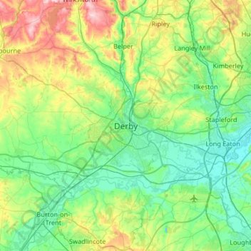
Name: Derby topographic map, elevation, terrain.
Average elevation: 97 m
Minimum elevation: 25 m
Maximum elevation: 317 m
Make a donation
Other topographic maps
Click on a map to view its topography, its elevation and its terrain.
Make a donation
Buxton
United Kingdom > England > Derbyshire > High Peak
Buxton has an oceanic climate with short, mild summers and long, cool winters. At about 1,000 feet (300 m) above sea level, As the highest market town in England, Buxton's elevation makes it cooler and wetter than surrounding towns, with a daytime temperature typically about 2 °C lower than Manchester.
Average elevation: 334 m
Make a donation
Make a donation
Make a donation
Tansley CP
United Kingdom > England > Derbyshire > Derbyshire Dales > Matlock
Average elevation: 219 m
Alfreton Park
United Kingdom > England > Derbyshire > Amber Valley > Alfreton CP > Oakerthorpe
Average elevation: 116 m
Make a donation
Grassmoor Country Park
United Kingdom > England > Derbyshire > North East Derbyshire > Corbriggs
Average elevation: 116 m
Mercia Marina
United Kingdom > England > Derbyshire > South Derbyshire > Willington CP
Average elevation: 51 m
Make a donation
Black Rocks
United Kingdom > England > Derbyshire > Derbyshire Dales > Cromford CP
Average elevation: 199 m
Make a donation
Make a donation
Make a donation
Staunton Harold Reservoir
United Kingdom > England > Derbyshire > South Derbyshire > Melbourne CP
Average elevation: 93 m
Hathersage
United Kingdom > England > Derbyshire > Derbyshire Dales
The Fat Boys Stanage Struggle is a popular local fell race that starts in Hathersage—altitude 91 metres (299 ft)—and routes up to and along Stanage Edge to High Neb—458 metres (1,503 ft)—before returning to the village 367 metres (1,204 ft) below.
Average elevation: 311 m
Make a donation
Ashover CP
United Kingdom > England > Derbyshire > North East Derbyshire
By the 18th century, there were several thousand acres of unenclosed moorland in the parish of Ashover, principally covered with heath. The only paths across this wilderness for roads were tracks in the sand or heath with here and there a stone post on the hills or elevations to serve as guides to the…
Average elevation: 210 m
Make a donation
Crowden Great Brook
United Kingdom > England > Derbyshire > High Peak > Tintwistle
Average elevation: 459 m
Make a donation
Norwood Cottage Lakes
United Kingdom > England > Derbyshire > North East Derbyshire > Killamarsh
Average elevation: 93 m
Rother Valley Country Park
United Kingdom > England > Derbyshire > Rotherham > Swallownest
Average elevation: 62 m
Make a donation
Stanage Plantation
United Kingdom > England > Derbyshire > Derbyshire Dales > Hathersage
Average elevation: 360 m
Make a donation
Make a donation
Derwent
United Kingdom > England > Derbyshire > High Peak > Bamford > Yorkshire Bridge
Average elevation: 291 m
Make a donation
New Mills
United Kingdom > England > Derbyshire > High Peak
High Peak Borough Council have produced a Conservation Area Character Appraisal document, outlining the reasons that the Conservation Area has been designated as such. In justifying the reasons for designation, this document states of the town: "New Mills is a town of dramatic topography and origins that date…
Average elevation: 251 m
Bonsall CP
United Kingdom > England > Derbyshire > Derbyshire Dales > Matlock
Average elevation: 225 m
Make a donation
Haddon Hall
United Kingdom > England > Derbyshire > Derbyshire Dales > Alport
Average elevation: 158 m
Derwent
United Kingdom > England > Derbyshire > High Peak > Bamford > Yorkshire Bridge
Average elevation: 287 m
Make a donation
Make a donation
Make a donation
Blackwell in the Peak CP
United Kingdom > England > Derbyshire > Derbyshire Dales
Average elevation: 331 m
Make a donation
Padley Gorge
United Kingdom > England > Derbyshire > Derbyshire Dales > Grindleford
Average elevation: 316 m
Make a donation
New Mills
United Kingdom > England > Derbyshire > High Peak
High Peak Borough Council have produced a Conservation Area Character Appraisal document, outlining the reasons that the Conservation Area has been designated as such. In justifying the reasons for designation, this document states of the town: "New Mills is a town of dramatic topography and origins that date…
Average elevation: 229 m
Make a donation
Bakewell CP
United Kingdom > England > Derbyshire > Derbyshire Dales
The Manchester, Buxton, Matlock and Midlands Junction Railway opened Bakewell railway station in 1862, then became part of the Midland Railway and later of the LMS main line from London to Manchester. John Ruskin objected to what he saw as desecration of the Derbyshire countryside and to the fact that "every…
Average elevation: 194 m
Make a donation
Make a donation