
Thank you for supporting this site ❤️
Make a donation
Make a donation
Charakas topographic map
Click on the map to display elevation.
Thank you for supporting this site ❤️
Make a donation
Make a donation
Charakas
The community of Charakas (Δημοτική Κοινότητα Χάρακος) consists of the village Charakas and the smaller villages Agia Fotia (Αγιά Φωτιά) (pop. 22, at elevation 275 m, 2 km to the West from Charakas) and Doraki (Δωράκι) (pop. 24, at elevation 310 m, 1.5 km to the East from Charakas).
Thank you for supporting this site ❤️
Make a donation
Make a donation
About this map
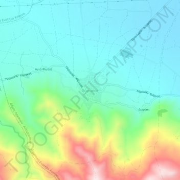
Name: Charakas topographic map, elevation, terrain.
Average elevation: 357 m
Minimum elevation: 220 m
Maximum elevation: 721 m
Thank you for supporting this site ❤️
Make a donation
Make a donation