
Thank you for supporting this site ❤️
Make a donation
Make a donation
Gabriola Island topographic map
Click on the map to display elevation.
Thank you for supporting this site ❤️
Make a donation
Make a donation
Gabriola Island
Gabriola is about 14 kilometres (9 mi) long by 4.2 kilometres (2.6 mi) wide on average with a land area of 57.6 square kilometres (22.2 sq mi). The topography varies from flat sandy beaches at sea level to forested hills rising to 160 metres (525 ft) on Stoney Ridge in the centre of the island.
Thank you for supporting this site ❤️
Make a donation
Make a donation
About this map
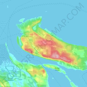
Name: Gabriola Island topographic map, elevation, terrain.
Average elevation: 26 m
Minimum elevation: -2 m
Maximum elevation: 174 m
Thank you for supporting this site ❤️
Make a donation
Make a donation