
Thank you for supporting this site ❤️
Make a donation
Make a donation
Penrhyn-coch topographic map
Click on the map to display elevation.
Thank you for supporting this site ❤️
Make a donation
Make a donation
About this map
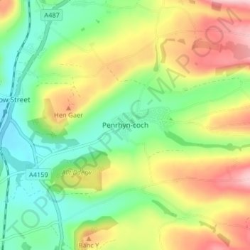
Name: Penrhyn-coch topographic map, elevation, terrain.
Location: Penrhyn-coch, Ceredigion, Wales, SY23 3TR, United Kingdom (52.41777 -4.01884 52.45777 -3.97884)
Average elevation: 98 m
Minimum elevation: 15 m
Maximum elevation: 217 m
Thank you for supporting this site ❤️
Make a donation
Make a donation
Other topographic maps
Click on a map to view its topography, its elevation and its terrain.
Thank you for supporting this site ❤️
Make a donation
Make a donation
Thank you for supporting this site ❤️
Make a donation
Make a donation
Newcastle Emlyn Castle
United Kingdom > Wales > Ceredigion > Adpar > Bryndioddef
Average elevation: 78 m
Thank you for supporting this site ❤️
Make a donation
Make a donation
Thank you for supporting this site ❤️
Make a donation
Make a donation