
Lake Mweru Wantipa topographic map
Interactive map
Click on the map to display elevation.
About this map
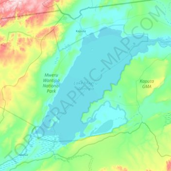
Name: Lake Mweru Wantipa topographic map, elevation, terrain.
Location: Lake Mweru Wantipa, Province Septentrionale, Zambie (-8.99169 29.44406 -8.45297 30.23010)
Average elevation: 1,044 m
Minimum elevation: 927 m
Maximum elevation: 1,625 m
Other topographic maps
Click on a map to view its topography, its elevation and its terrain.
Mbala
Zambie > Province Septentrionale
Mbala, Mbala District, Province Septentrionale, Zambie
Average elevation: 1,632 m
Kaputa
Zambie > Province Septentrionale > Kaputa
Kaputa, Province Septentrionale, Zambie
Average elevation: 948 m