
Provence topographic map
Interactive map
Click on the map to display elevation.
About this map
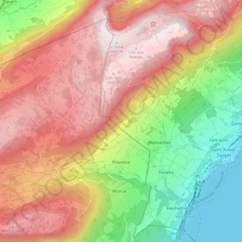
Name: Provence topographic map, elevation, terrain.
Average elevation: 971 m
Minimum elevation: 422 m
Maximum elevation: 1,459 m
Other topographic maps
Click on a map to view its topography, its elevation and its terrain.
Jura Suisse
Zwitserland > Waadland > District du Jura-Nord vaudois > Tévenon
Jura Suisse, Tévenon, District du Jura-Nord vaudois, Waadland, 2112, Zwitserland
Average elevation: 1,213 m
Vallorbe
Zwitserland > Waadland > District du Jura-Nord vaudois
Vallorbe, District du Jura-Nord vaudois, Waadland, 1337, Zwitserland
Average elevation: 1,056 m