
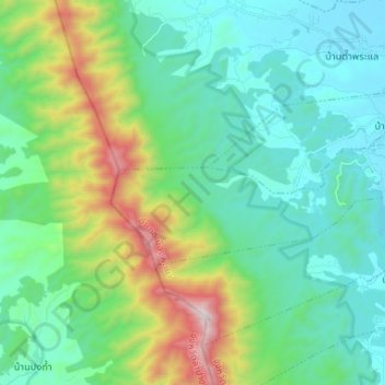
San Pa Muang Subdistrict topographic map
Interactive map
Click on the map to display elevation.
About this map
Name: San Pa Muang Subdistrict topographic map, elevation, terrain.
Average elevation: 699 m
Minimum elevation: 400 m
Maximum elevation: 1,666 m
Other topographic maps
Click on a map to view its topography, its elevation and its terrain.
Ban Muang
Thailand > Phayao Province > Mueang Phayao District > Ban Mai Subdistrict > Ban Mai Nakhon > Ban Muang
Ban Muang, Ban Mai Nakhon, Ban Mai Subdistrict, Ban Mai, Mueang Phayao District, Phayao Province, Thailand
Average elevation: 403 m