
Thank you for supporting this site ❤️
Make a donation
Make a donation
Alytus County topographic map
Click on the map to display elevation.
Thank you for supporting this site ❤️
Make a donation
Make a donation
About this map
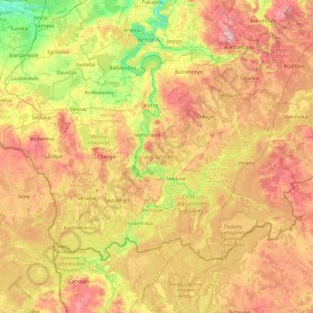
Name: Alytus County topographic map, elevation, terrain.
Location: Alytus County, Lithuania (53.89679 23.31195 54.56348 25.02498)
Average elevation: 125 m
Minimum elevation: 39 m
Maximum elevation: 251 m
Thank you for supporting this site ❤️
Make a donation
Make a donation
Other topographic maps
Click on a map to view its topography, its elevation and its terrain.