
Sargans topographic map
Interactive map
Click on the map to display elevation.
About this map
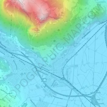
Name: Sargans topographic map, elevation, terrain.
Location: Sargans, Wahlkreis Sarganserland, St. Gallen, 7320, Schweiz (47.03988 9.41853 47.06885 9.47725)
Average elevation: 707 m
Minimum elevation: 472 m
Maximum elevation: 1,851 m
Sargans liegt am Schnittpunkt des Alpenrheintals, das hier von Südosten nach Nordosten abbiegt, und dem Seeztal, das das Tal des Alpenrheins ohne nennenswerten Höhenunterschied mit dem Zürichsee verbindet.
Other topographic maps
Click on a map to view its topography, its elevation and its terrain.
Mels
Schweiz > St. Gallen > Wahlkreis Sarganserland
Mels, Wahlkreis Sarganserland, St. Gallen, Schweiz
Average elevation: 1,317 m
Flums
Schweiz > St. Gallen > Wahlkreis Sarganserland
Flums, Wahlkreis Sarganserland, St. Gallen, Schweiz
Average elevation: 1,328 m