Middle Tennessee topographic map
Click on the map to display elevation.
Middle Tennessee
The Highland Rim is often divided into eastern and western halves. The Eastern Highland Rim is relatively flat, with gentle rolling hills, and the eastern Nashville Basin has similar terrain but is dotted with more distinct hills in places. The western Nashville Basin and Western Highland Rim are more rugged, consisting of irregular knob-like hills separated by steep ravines and crooked stream valleys. The eastern Highland Rim has a higher average elevation, however, than the western portion. The eastern portion of Middle Tennessee consists of the western portion of the Cumberland Plateau, part of the larger Appalachian Plateau of the Appalachian Mountains.
About this map
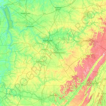
Name: Middle Tennessee topographic map, elevation, terrain.
Location: Middle Tennessee, Tennessee, United States (34.98825 -88.07053 36.67812 -84.65953)
Average elevation: 251 m
Minimum elevation: 96 m
Maximum elevation: 874 m
Other topographic maps
Click on a map to view its topography, its elevation and its terrain.















Eastdale
United States > Tennessee > Hamilton County > Chattanooga > Ridgeside
Average elevation: 237 m





Ridgedale
United States > Tennessee > Hamilton County > Chattanooga > Ridgeside
Average elevation: 234 m






Barfield Crescent Park
United States > Tennessee > Rutherford County > Murfreesboro
Average elevation: 201 m



Brainerd
United States > Tennessee > Hamilton County > Chattanooga > Ridgeside
Average elevation: 234 m

Millersville City Park
United States > Tennessee > Robertson County > Millersville
Average elevation: 260 m