
Rutland County topographic map
Interactive map
Click on the map to display elevation.
About this map
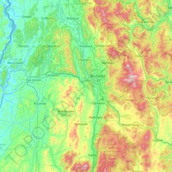
Name: Rutland County topographic map, elevation, terrain.
Location: Rutland County, Vermont, United States (43.29055 -73.43139 43.85806 -72.69980)
Average elevation: 367 m
Minimum elevation: 25 m
Maximum elevation: 1,258 m
Other topographic maps
Click on a map to view its topography, its elevation and its terrain.
Bakersfield
United States > Vermont > Franklin County
Bakersfield, Franklin County, Vermont, 05441, United States
Average elevation: 288 m