
Thank you for supporting this site ❤️
Make a donation
Make a donation
Le Petit Andely topographic map
Click on the map to display elevation.
Thank you for supporting this site ❤️
Make a donation
Make a donation
About this map
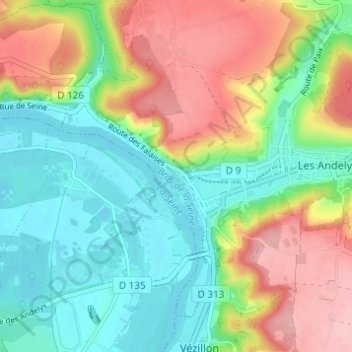
Name: Le Petit Andely topographic map, elevation, terrain.
Average elevation: 68 m
Minimum elevation: 7 m
Maximum elevation: 164 m
Thank you for supporting this site ❤️
Make a donation
Make a donation
Other topographic maps
Click on a map to view its topography, its elevation and its terrain.
Château Gaillard
France > Normandie > Eure > Les Andelys > Le Petit Andely
Les ruines de Château-Gaillard sont situées sur une falaise de calcaire dominant un grand méandre de la Seine et le bourg des Andelys, dans le département français de l'Eure, en France. Son altitude est environ de 90 à 100 mètres.
Average elevation: 62 m