
Thank you for supporting this site ❤️
Make a donation
Make a donation
Grad Rijeka topographic map
Click on the map to display elevation.
Thank you for supporting this site ❤️
Make a donation
Make a donation
Grad Rijeka
Since records began in 1948, the highest temperature recorded at the local weather station at an elevation of 120 metres (390 ft) was 40.0 °C (104.0 °F), on 19 July 2007. The coldest temperature was −12.8 °C (9.0 °F), on 10 February 1956.
Thank you for supporting this site ❤️
Make a donation
Make a donation
About this map
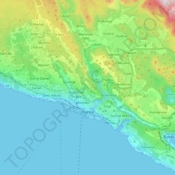
Name: Grad Rijeka topographic map, elevation, terrain.
Location: Grad Rijeka, Primorje-Gorski Kotar County, Croatia (45.30744 14.33193 45.38405 14.53097)
Average elevation: 209 m
Minimum elevation: -1 m
Maximum elevation: 977 m
Thank you for supporting this site ❤️
Make a donation
Make a donation
Other topographic maps
Click on a map to view its topography, its elevation and its terrain.
Thank you for supporting this site ❤️
Make a donation
Make a donation
Thank you for supporting this site ❤️
Make a donation
Make a donation
Thank you for supporting this site ❤️
Make a donation
Make a donation
Thank you for supporting this site ❤️
Make a donation
Make a donation
Thank you for supporting this site ❤️
Make a donation
Make a donation
Thank you for supporting this site ❤️
Make a donation
Make a donation
Thank you for supporting this site ❤️
Make a donation
Make a donation