
Capel topographic map
Click on the map to display elevation.
About this map
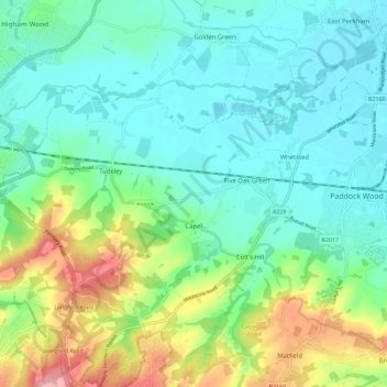
Name: Capel topographic map, elevation, terrain.
Location: Capel, Tunbridge Wells, Kent, England, United Kingdom (51.16121 0.27548 51.20162 0.38881)
Average elevation: 47 m
Minimum elevation: 10 m
Maximum elevation: 142 m
Other topographic maps
Click on a map to view its topography, its elevation and its terrain.
Underground reservoir
United Kingdom > England > Kent > Tunbridge Wells > Hartley > Flishinghurst
Average elevation: 103 m
Chalybeate Spring
United Kingdom > England > Kent > Tunbridge Wells > Kilndown
Average elevation: 65 m
Rusthall Common Cricket Ground
United Kingdom > England > Kent > Tunbridge Wells > Rusthall
Average elevation: 99 m
Bedgebury National Pinetum
United Kingdom > England > Kent > Tunbridge Wells > Kilndown
Average elevation: 91 m