
Thank you for supporting this site ❤️
Make a donation
Make a donation
Onllwyn topographic map
Click on the map to display elevation.
Thank you for supporting this site ❤️
Make a donation
Make a donation
About this map
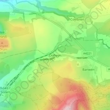
Name: Onllwyn topographic map, elevation, terrain.
Location: Onllwyn, Neath Port Talbot, Wales, SA10 9HG, United Kingdom (51.75970 -3.70073 51.79970 -3.66073)
Average elevation: 257 m
Minimum elevation: 137 m
Maximum elevation: 441 m
Thank you for supporting this site ❤️
Make a donation
Make a donation
Other topographic maps
Click on a map to view its topography, its elevation and its terrain.
Thank you for supporting this site ❤️
Make a donation
Make a donation
Thank you for supporting this site ❤️
Make a donation
Make a donation