
Gubur Dhaura topographic map
Interactive map
Click on the map to display elevation.
About this map
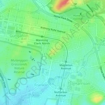
Name: Gubur Dhaura topographic map, elevation, terrain.
Average elevation: 622 m
Minimum elevation: 604 m
Maximum elevation: 665 m
Other topographic maps
Click on a map to view its topography, its elevation and its terrain.
Taylor
Australia > District of Gungahlin
Taylor, District of Gungahlin, Australian Capital Territory, Australia
Average elevation: 693 m
Casey
Australia > District of Gungahlin
Casey, District of Gungahlin, Australian Capital Territory, Australia
Average elevation: 660 m
Bonner
Australia > District of Gungahlin
Bonner, District of Gungahlin, Australian Capital Territory, Australia
Average elevation: 655 m
Throsby
Australia > District of Gungahlin
Throsby, District of Gungahlin, Australian Capital Territory, Australia
Average elevation: 632 m
Ngunnawal
Australia > District of Gungahlin
Ngunnawal, District of Gungahlin, Australian Capital Territory, 2913, Australia
Average elevation: 631 m
Nicholls
Australia > District of Gungahlin
Nicholls, District of Gungahlin, Australian Capital Territory, Australia
Average elevation: 622 m
Crace
Australia > District of Gungahlin
Crace, District of Gungahlin, Australian Capital Territory, 2911, Australia
Average elevation: 614 m
Forde
Australia > District of Gungahlin
Forde, District of Gungahlin, Australian Capital Territory, Australia
Average elevation: 639 m
Amaroo
Australia > District of Gungahlin
Amaroo, District of Gungahlin, Australian Capital Territory, Australia
Average elevation: 629 m
Palmerston
Australia > District of Gungahlin
Palmerston, District of Gungahlin, Australian Capital Territory, Australia
Average elevation: 615 m
Harrison
Australia > District of Gungahlin
Harrison, District of Gungahlin, Australian Capital Territory, Australia
Average elevation: 620 m
Franklin
Australia > District of Gungahlin
Franklin, District of Gungahlin, Australian Capital Territory, Australia
Average elevation: 616 m
Moncrieff
Australia > District of Gungahlin
Moncrieff, District of Gungahlin, Australian Capital Territory, Australia
Average elevation: 644 m