
Make a donation
Union topographic map
Click on the map to display elevation.
Make a donation
About this map
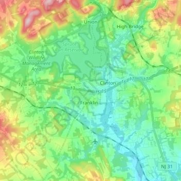
Name: Union topographic map, elevation, terrain.
Location: Union, Hunterdon County, New Jersey, United States (40.58343 -75.04588 40.68047 -74.91603)
Average elevation: 111 m
Minimum elevation: 42 m
Maximum elevation: 278 m
Make a donation
Other topographic maps
Click on a map to view its topography, its elevation and its terrain.
Centerville
United States > New Jersey > Hunterdon County > Readington Township
Average elevation: 49 m
Make a donation
Wertsville
United States > New Jersey > Hunterdon County > East Amwell Township
Average elevation: 72 m
Make a donation
Rileyville
United States > New Jersey > Hunterdon County > East Amwell Township
Average elevation: 125 m
Make a donation
Whitehouse Station
United States > New Jersey > Hunterdon County > Readington Township
Average elevation: 61 m
Pleasant Run
United States > New Jersey > Hunterdon County > Readington Township
Average elevation: 63 m
Make a donation
Larisons Corners
United States > New Jersey > Hunterdon County > Larisons Corners
Average elevation: 66 m
Make a donation