
Capileira topographic map
Interactive map
Click on the map to display elevation.
About this map
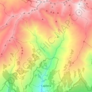
Name: Capileira topographic map, elevation, terrain.
Average elevation: 2,384 m
Minimum elevation: 1,117 m
Maximum elevation: 3,472 m
Capileira is the highest and most northerly of the three villages in the gorge of the Poqueira river in the La Alpujarra district of the province of Granada, in Spain. It is located at latitude 36° 57' N and longitude 3° 21' W, about 1 km north of Bubión. Its altitude is officially recorded as 1436 metres, though there is a considerable altitude difference between the oldest part of the village, which is at the lower, southern end, and the highest part, where tourist-oriented development is currently concentrated. The area of the municipality is 57 km².
Other topographic maps
Click on a map to view its topography, its elevation and its terrain.
Sierra Nevada
Spain > Andalusia > Comarca de la Alpujarra Granadina > Lanjarón
Sierra Nevada, Lanjarón, Comarca de la Alpujarra Granadina, Granada, Andalusia, Spain
Average elevation: 2,223 m
Órgiva
Spain > Andalusia > Comarca de la Alpujarra Granadina
Órgiva, Comarca de la Alpujarra Granadina, Granada, Andalusia, Spain
Average elevation: 823 m
Pico de Mulhacén
Spain > Andalusia > Comarca de la Alpujarra Granadina > Trevélez
Pico de Mulhacén, Trevélez, Comarca de la Alpujarra Granadina, Granada, Andalusia, Spain
Average elevation: 3,070 m
Mecina Bombarón
Spain > Andalusia > Comarca de la Alpujarra Granadina > Alpujarra de la Sierra > Mecina Bombarón
Mecina Bombarón, Alpujarra de la Sierra, Comarca de la Alpujarra Granadina, Granada, Andalusia, 18450, Spain
Average elevation: 1,292 m
Cáñar
Spain > Andalusia > Comarca de la Alpujarra Granadina
Cáñar, Comarca de la Alpujarra Granadina, Granada, Andalusia, Spain
Average elevation: 1,816 m
Lobras
Spain > Andalusia > Comarca de la Alpujarra Granadina
Lobras, Comarca de la Alpujarra Granadina, Granada, Andalusia, 18449, Spain
Average elevation: 1,036 m