
Thank you for supporting this site ❤️
Make a donation
Make a donation
Framnäs topographic map
Click on the map to display elevation.
Thank you for supporting this site ❤️
Make a donation
Make a donation
About this map
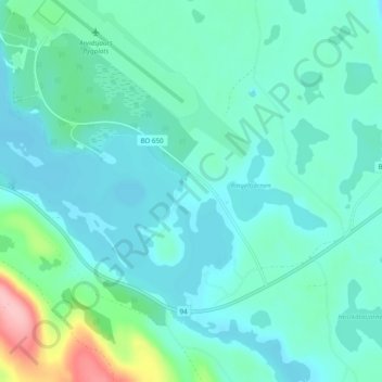
Name: Framnäs topographic map, elevation, terrain.
Location: Framnäs, Arvidsjaurs kommun, Norrbotten County, Sweden (65.55532 19.28079 65.59532 19.32079)
Average elevation: 376 m
Minimum elevation: 352 m
Maximum elevation: 492 m
Thank you for supporting this site ❤️
Make a donation
Make a donation
Other topographic maps
Click on a map to view its topography, its elevation and its terrain.
Thank you for supporting this site ❤️
Make a donation
Make a donation
Abisko National Park
Permafrost is common in the national park, though permafrost at lower elevations is disappearing because of global warming and increased snowfall.
Average elevation: 740 m
Thank you for supporting this site ❤️
Make a donation
Make a donation
Thank you for supporting this site ❤️
Make a donation
Make a donation
Thank you for supporting this site ❤️
Make a donation
Make a donation
Torneträsk
Permafrost is common in the land around the lake. This low elevation permafrost is disappearing because of global warming and increased snowfall.
Average elevation: 768 m
Thank you for supporting this site ❤️
Make a donation
Make a donation
Thank you for supporting this site ❤️
Make a donation
Make a donation
Thank you for supporting this site ❤️
Make a donation
Make a donation
Thank you for supporting this site ❤️
Make a donation
Make a donation