
Thank you for supporting this site ❤️
Make a donation
Make a donation
Campbell Hill topographic map
Click on the map to display elevation.
Thank you for supporting this site ❤️
Make a donation
Make a donation
Campbell Hill
Campbell Hill is, at 1,549.09 feet (472.16 m), the highest point in elevation in the U.S. state of Ohio. Campbell Hill is located within the city of Bellefontaine, 2 miles (3.2 km) northeast of downtown.
Thank you for supporting this site ❤️
Make a donation
Make a donation
About this map
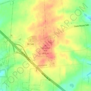
Name: Campbell Hill topographic map, elevation, terrain.
Average elevation: 444 m
Minimum elevation: 411 m
Maximum elevation: 471 m
Thank you for supporting this site ❤️
Make a donation
Make a donation