
Thank you for supporting this site ❤️
Make a donation
Make a donation
Soum d'Aulet topographic map
Click on the map to display elevation.
Thank you for supporting this site ❤️
Make a donation
Make a donation
About this map
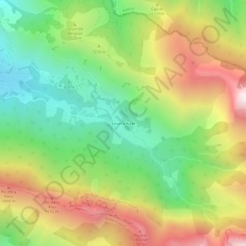
Name: Soum d'Aulet topographic map, elevation, terrain.
Average elevation: 1,161 m
Minimum elevation: 565 m
Maximum elevation: 1,953 m
Thank you for supporting this site ❤️
Make a donation
Make a donation
Other topographic maps
Click on a map to view its topography, its elevation and its terrain.
Lac du Montagnon
France > Nouvelle-Aquitaine > Pyrénées-Atlantiques > Accous
Average elevation: 1,771 m