
Coffee County topographic map
Interactive map
Click on the map to display elevation.
About this map
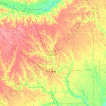
Name: Coffee County topographic map, elevation, terrain.
Location: Coffee County, Georgia, United States of America (31.36345 -83.15118 31.81064 -82.59641)
Average elevation: 72 m
Minimum elevation: 31 m
Maximum elevation: 112 m
Other topographic maps
Click on a map to view its topography, its elevation and its terrain.
Evans County
United States of America > Georgia
Evans County, Georgia, United States of America
Average elevation: 47 m
Murray County
United States of America > Georgia
Murray County, Georgia, United States of America
Average elevation: 381 m
Bibb County
United States of America > Georgia
Bibb County, Georgia, United States of America
Average elevation: 128 m