
Kalouga topographic map
Interactive map
Click on the map to display elevation.
About this map
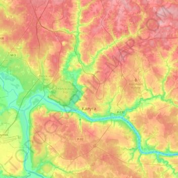
Name: Kalouga topographic map, elevation, terrain.
Average elevation: 184 m
Minimum elevation: 108 m
Maximum elevation: 254 m
Other topographic maps
Click on a map to view its topography, its elevation and its terrain.
Kalouga
Russie > Oblast de Kalouga > городской округ Калуга > Kalouga
Kalouga, городской округ Калуга, Oblast de Kalouga, District fédéral central, 248610, Russie
Average elevation: 185 m