
Bonifacio topographic map
Interactive map
Click on the map to display elevation.
About this map
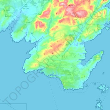
Name: Bonifacio topographic map, elevation, terrain.
Average elevation: 49 m
Minimum elevation: -5 m
Maximum elevation: 339 m
The city and its fortifications also extend for some distance along the cliff-tops, which are at about 70 meters (230 ft) elevation. The cliffs have been undercut by the ocean so that the buildings, which have been placed on the very lip of the precipice, appear to overhang it. The appearance from the sea is of a white city gleaming in the sun and suspended over the rough waters below.
Other topographic maps
Click on a map to view its topography, its elevation and its terrain.
Casile
France > Corsica > South Corsica > Valle-di-Mezzana > Casile
Casile, Valle-di-Mezzana, Ajaccio, South Corsica, Corsica, Metropolitan France, 20167, France
Average elevation: 453 m