
Baldwin County topographic map
Interactive map
Click on the map to display elevation.
About this map
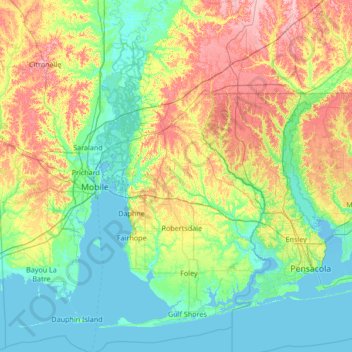
Name: Baldwin County topographic map, elevation, terrain.
Location: Baldwin County, Alabama, United States of America (30.13752 -88.06227 31.30329 -87.37158)
Average elevation: 31 m
Minimum elevation: -4 m
Maximum elevation: 116 m
Other topographic maps
Click on a map to view its topography, its elevation and its terrain.
Rock Creek
United States of America > Alabama > Rock Creek
Rock Creek, Jefferson County, Alabama, United States of America
Average elevation: 148 m
Elmore County
United States of America > Alabama
Elmore County, Alabama, United States of America
Average elevation: 113 m