
Thank you for supporting this site ❤️
Make a donation
Make a donation
Barry County topographic map
Click on the map to display elevation.
Thank you for supporting this site ❤️
Make a donation
Make a donation
About this map
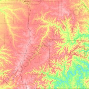
Name: Barry County topographic map, elevation, terrain.
Location: Barry County, Missouri, United States (36.49867 -94.07719 36.93364 -93.57398)
Average elevation: 402 m
Minimum elevation: 272 m
Maximum elevation: 511 m
Thank you for supporting this site ❤️
Make a donation
Make a donation
Other topographic maps
Click on a map to view its topography, its elevation and its terrain.