
Aosta topographic map
Interactive map
Click on the map to display elevation.
About this map
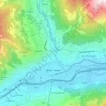
Name: Aosta topographic map, elevation, terrain.
Location: Aosta, Aostatal, 11100, Italien (45.72626 7.23862 45.77265 7.34795)
Average elevation: 980 m
Minimum elevation: 537 m
Maximum elevation: 2,476 m
Other topographic maps
Click on a map to view its topography, its elevation and its terrain.
Matterhorn
Italien > Aostatal > Valtournenche
Matterhorn, Valtournenche, Aostatal, Italien
Average elevation: 3,295 m
Courmayeur
Italien > Aostatal > Courmayeur
Courmayeur, Aostatal, 11013, Italien
Average elevation: 2,366 m
Valtournenche
Italien > Aostatal > Valtournenche
Valtournenche, Aostatal, Italien
Average elevation: 2,640 m
Valsavarenche
Italien > Aostatal > Valsavarenche
Valsavarenche, Aostatal, 11010, Italien
Average elevation: 2,543 m
Dora di Ferret
Italien > Aostatal > Courmayeur
Dora di Ferret, Courmayeur, Aostatal, Italien
Average elevation: 2,332 m
Nationalpark Gran Paradiso
Nationalpark Gran Paradiso, 22, David, Cogne, Aostatal, Italien
Average elevation: 2,133 m