
Thank you for supporting this site ❤️
Make a donation
Make a donation
Westlake topographic map
Click on the map to display elevation.
Thank you for supporting this site ❤️
Make a donation
Make a donation
About this map
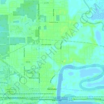
Name: Westlake topographic map, elevation, terrain.
Location: Westlake, Calcasieu Parish, Louisiana, 70669, United States (30.23471 -93.28374 30.28622 -93.24564)
Average elevation: 6 m
Minimum elevation: -1 m
Maximum elevation: 15 m
Thank you for supporting this site ❤️
Make a donation
Make a donation
Other topographic maps
Click on a map to view its topography, its elevation and its terrain.