
Thank you for supporting this site ❤️
Make a donation
Make a donation
McCullom Lake topographic map
Click on the map to display elevation.
Thank you for supporting this site ❤️
Make a donation
Make a donation
About this map
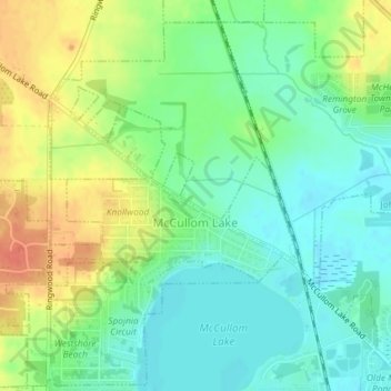
Name: McCullom Lake topographic map, elevation, terrain.
Location: McCullom Lake, McHenry County, Illinois, United States (42.36399 -88.30609 42.37645 -88.28437)
Average elevation: 244 m
Minimum elevation: 226 m
Maximum elevation: 272 m
Thank you for supporting this site ❤️
Make a donation
Make a donation
Other topographic maps
Click on a map to view its topography, its elevation and its terrain.
Riley
United States > Illinois > McHenry County
Riley, elevation 807 feet (246 m), is an unincorporated community and census-designated place in McHenry County, Illinois, United States. It was named a CDP before the 2020 census, at which time it had a population of 10.
Average elevation: 250 m
Thank you for supporting this site ❤️
Make a donation
Make a donation