
Stein (AR) topographic map
Interactive map
Click on the map to display elevation.
About this map
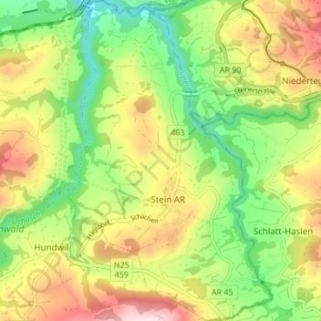
Name: Stein (AR) topographic map, elevation, terrain.
Average elevation: 769 m
Minimum elevation: 596 m
Maximum elevation: 994 m
Other topographic maps
Click on a map to view its topography, its elevation and its terrain.
Stein AR
Suisse > Appenzell Rhodes-Extérieures > Hinterland > Stein (AR)
Stein AR, Stein (AR), Hinterland, Appenzell Rhodes-Extérieures, 9063, Suisse
Average elevation: 777 m
Hundwil
Suisse > Appenzell Rhodes-Extérieures > Hinterland > Hundwil > Hundwil
Hundwil, Hinterland, Appenzell Rhodes-Extérieures, 9064, Suisse
Average elevation: 831 m