
Thank you for supporting this site ❤️
Make a donation
Make a donation
Lago Bayano topographic map
Click on the map to display elevation.
Thank you for supporting this site ❤️
Make a donation
Make a donation
About this map
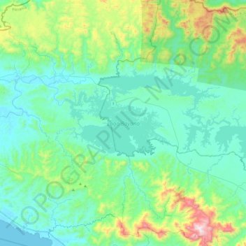
Name: Lago Bayano topographic map, elevation, terrain.
Location: Lago Bayano, Distrito Chepo, Panamá (9.02143 -78.89023 9.24942 -78.43997)
Average elevation: 198 m
Minimum elevation: 0 m
Maximum elevation: 1,065 m
Thank you for supporting this site ❤️
Make a donation
Make a donation
Other topographic maps
Click on a map to view its topography, its elevation and its terrain.
Higueronal Arriba
Panamá > Panamá > Distrito Chepo > Tortí > Higueronal Arriba
Average elevation: 207 m