
Sòssu/Sorso topographic map
Interactive map
Click on the map to display elevation.
About this map
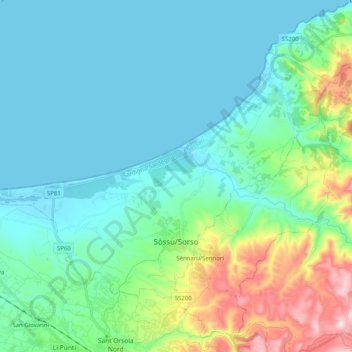
Name: Sòssu/Sorso topographic map, elevation, terrain.
Location: Sòssu/Sorso, Sassari, Sardenha, 07037, Itália (40.77129 8.46440 40.87843 8.66594)
Average elevation: 107 m
Minimum elevation: -1 m
Maximum elevation: 532 m
Other topographic maps
Click on a map to view its topography, its elevation and its terrain.
Arboriamar
Itália > Sardenha > Sassari > Sòssu/Sorso
Arboriamar, Sòssu/Sorso, Sassari, Sardenha, 07037, Itália
Average elevation: 22 m
Zelgu/Tergu
Zelgu/Tergu, Sassari, Sardenha, 07030, Itália
Average elevation: 314 m