
Taxiarches topographic map
Interactive map
Click on the map to display elevation.
About this map
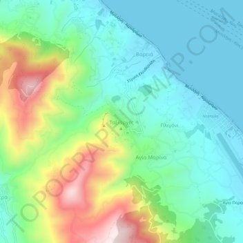
Name: Taxiarches topographic map, elevation, terrain.
Average elevation: 149 m
Minimum elevation: 0 m
Maximum elevation: 498 m
Other topographic maps
Click on a map to view its topography, its elevation and its terrain.
Vareia
Greece > Aegean > Lesbos Regional Unit > Mytilene Municipal Unit
Vareia, Mytilene Municipal Unit, Municipality of Mytilene, Lesbos Regional Unit, Northern Aegean, Aegean, 811 00, Greece
Average elevation: 66 m