
Thank you for supporting this site ❤️
Make a donation
Make a donation
Bolintin-Vale topographic map
Click on the map to display elevation.
Thank you for supporting this site ❤️
Make a donation
Make a donation
Bolintin-Vale
The town is situated in the Wallachian Plain, at an altitude of 100 m (330 ft), on the banks of the Sabar River.
Thank you for supporting this site ❤️
Make a donation
Make a donation
About this map
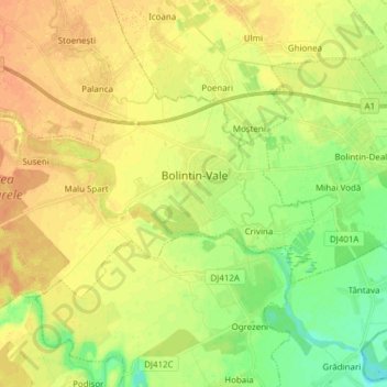
Name: Bolintin-Vale topographic map, elevation, terrain.
Location: Bolintin-Vale, Giurgiu, 085100, Romania (44.41249 25.65283 44.47218 25.80595)
Average elevation: 107 m
Minimum elevation: 89 m
Maximum elevation: 121 m
Thank you for supporting this site ❤️
Make a donation
Make a donation
Other topographic maps
Click on a map to view its topography, its elevation and its terrain.
Thank you for supporting this site ❤️
Make a donation
Make a donation
Thank you for supporting this site ❤️
Make a donation
Make a donation