
Kasba topographic map
Interactive map
Click on the map to display elevation.
About this map
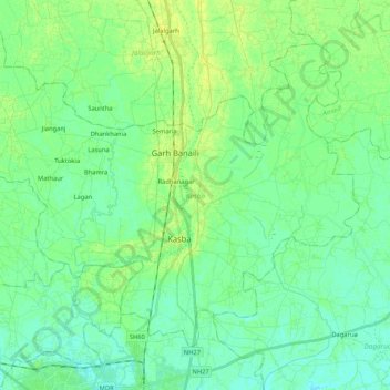
Name: Kasba topographic map, elevation, terrain.
Location: Kasba, Purnia district, Bihar, Inde (25.80507 87.42564 25.95141 87.63519)
Average elevation: 41 m
Minimum elevation: 35 m
Maximum elevation: 48 m
Other topographic maps
Click on a map to view its topography, its elevation and its terrain.
Sahebpur Kamal
Inde > Bihar > Sahebpur Kamal
Sahebpur Kamal, Begusarai, Bihar, 851217, Inde
Average elevation: 40 m
Patna
Inde > Bihar > Patna Rural
Patna, Patna Rural, Patna District, Bihar, 800001, Inde
Average elevation: 51 m
Gaya
Inde > Bihar > Gaya Town C.D.Block
Gaya, Gaya Town C.D.Block, Gaya District, Bihar, 823001, Inde
Average elevation: 111 m
Bagmati River
Bagmati River, Sītāmarhi, Sitamarhi, Bihar, 843321, Inde
Average elevation: 422 m