
Sun Prairie topographic map
Click on the map to display elevation.
Sun Prairie
The landscape of the city consists mostly of gently rolling hills and plains. The elevation of the city averages about 984 feet (300 m) above mean sea level.
About this map
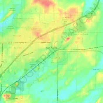
Name: Sun Prairie topographic map, elevation, terrain.
Location: Sun Prairie, Dane County, Wisconsin, United States (43.15056 -89.28821 43.21056 -89.18119)
Average elevation: 293 m
Minimum elevation: 272 m
Maximum elevation: 320 m
Other topographic maps
Click on a map to view its topography, its elevation and its terrain.
Walking Iron County Park
United States > Wisconsin > Dane County > Town of Mazomanie
Average elevation: 236 m
Deansville Wildlife Area
United States > Wisconsin > Dane County > Town of York
Average elevation: 264 m
Isthmus Path Prairie Garden
United States > Wisconsin > Dane County > Madison
Average elevation: 262 m