
Thank you for supporting this site ❤️
Make a donation
Make a donation
Pwllheli topographic map
Click on the map to display elevation.
Thank you for supporting this site ❤️
Make a donation
Make a donation
About this map
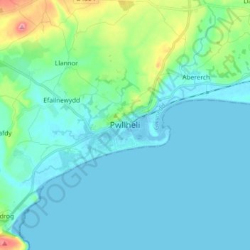
Name: Pwllheli topographic map, elevation, terrain.
Location: Pwllheli, Gwynedd, Wales, LL53 5DA, United Kingdom (52.84791 -4.45876 52.92791 -4.37876)
Average elevation: 22 m
Minimum elevation: -1 m
Maximum elevation: 147 m
Thank you for supporting this site ❤️
Make a donation
Make a donation
Other topographic maps
Click on a map to view its topography, its elevation and its terrain.