
Mesnils-sur-Iton topographic map
Interactive map
Click on the map to display elevation.
About this map
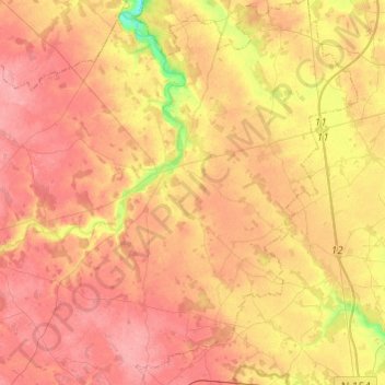
Name: Mesnils-sur-Iton topographic map, elevation, terrain.
Average elevation: 157 m
Minimum elevation: 108 m
Maximum elevation: 183 m
Other topographic maps
Click on a map to view its topography, its elevation and its terrain.
Grandvilliers
France > Normandie > Mesnils-sur-Iton
Grandvilliers, Mesnils-sur-Iton, Bernay, Eure, Normandie, France métropolitaine, 27240, France
Average elevation: 167 m