
Thank you for supporting this site ❤️
Make a donation
Make a donation
Tablat topographic map
Click on the map to display elevation.
Thank you for supporting this site ❤️
Make a donation
Make a donation
About this map
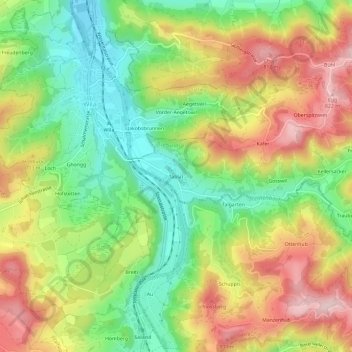
Name: Tablat topographic map, elevation, terrain.
Location: Tablat, Turbenthal, Bezirk Winterthur, Zürich, 8492, Schweiz (47.39176 8.83983 47.43176 8.87983)
Average elevation: 677 m
Minimum elevation: 553 m
Maximum elevation: 823 m
Thank you for supporting this site ❤️
Make a donation
Make a donation