
Thank you for supporting this site ❤️
Make a donation
Make a donation
Kecamatan Praya Barat topographic map
Click on the map to display elevation.
Thank you for supporting this site ❤️
Make a donation
Make a donation
About this map
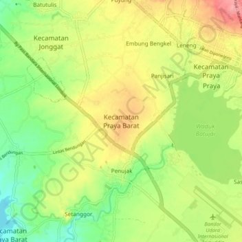
Name: Kecamatan Praya Barat topographic map, elevation, terrain.
Average elevation: 94 m
Minimum elevation: 51 m
Maximum elevation: 143 m
Thank you for supporting this site ❤️
Make a donation
Make a donation
Other topographic maps
Click on a map to view its topography, its elevation and its terrain.
REBAN BISOK BOKAH
Indonesia > West Nusa Tenggara > Lombok Tengah > Batas Desa Bebuak > Dusun Apit Aik
Average elevation: 400 m
Sungai Pandan
Indonesia > West Nusa Tenggara > Lombok Tengah > Kecamatan Praya Barat Daya
Average elevation: 73 m
Thank you for supporting this site ❤️
Make a donation
Make a donation
Batas Dusn montong Bulok
Indonesia > West Nusa Tenggara > Lombok Tengah > BATAS DESA MONTONG GAMANG
Average elevation: 342 m