
Eastleigh topographic map
Interactive map
Click on the map to display elevation.
About this map
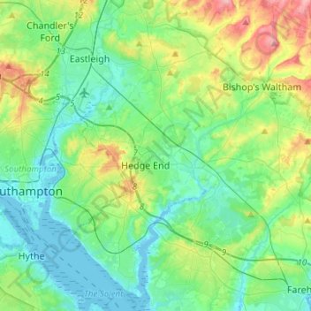
Name: Eastleigh topographic map, elevation, terrain.
Location: Eastleigh, Hampshire, England, United Kingdom (50.84202 -1.39281 50.99845 -1.25817)
Average elevation: 33 m
Minimum elevation: -4 m
Maximum elevation: 126 m
Other topographic maps
Click on a map to view its topography, its elevation and its terrain.
Bursledon
United Kingdom > England > Hampshire > Eastleigh
Bursledon, Eastleigh, Hampshire, South East England, England, United Kingdom
Average elevation: 28 m