
Thank you for supporting this site ❤️
Make a donation
Make a donation
Hillensberg topographic map
Click on the map to display elevation.
Thank you for supporting this site ❤️
Make a donation
Make a donation
Hillensberg
Het dorp ligt op een hoogte van ongeveer 82 meter. De hoofdstraat (Bergstrasse) loopt via een steilrand omhoog naar het Plateau van Doenrade. De weg stijgt daarbij van 62 naar 98 meter. Met 101,6 meter is de Schlouner Berg het hoogste punt van de gemeente Selfkant, waar Hillensberg deel van uitmaakt.
Thank you for supporting this site ❤️
Make a donation
Make a donation
About this map
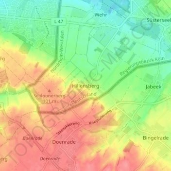
Name: Hillensberg topographic map, elevation, terrain.
Average elevation: 77 m
Minimum elevation: 42 m
Maximum elevation: 112 m
Thank you for supporting this site ❤️
Make a donation
Make a donation