
Collombey-Muraz topographic map
Interactive map
Click on the map to display elevation.
About this map
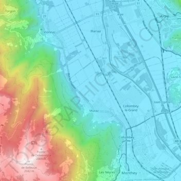
Name: Collombey-Muraz topographic map, elevation, terrain.
Location: Collombey-Muraz, Monthey, Valais, 1893, Suisse (46.24943 6.85446 46.32444 6.96228)
Average elevation: 562 m
Minimum elevation: 372 m
Maximum elevation: 1,979 m
Le point culminant du territoire communal, La Pointe de Bellevue à 2 042 m d'altitude, offre une vue du lac Léman aux dents du Midi. Depuis 2013, ce sommet donne son nom à une course pédestre populaire.
Other topographic maps
Click on a map to view its topography, its elevation and its terrain.
Saint-Gingolph
Saint-Gingolph, Monthey, Valais, 1898, Suisse
Average elevation: 1,104 m
Val-d'Illiez
Val-d'Illiez, Monthey, Valais, 1873, Suisse
Average elevation: 1,672 m
Troistorrents
Troistorrents, Monthey, Valais, Suisse
Average elevation: 1,231 m
Port-Valais
Suisse > Valais > Monthey > Port-Valais
Port-Valais, Monthey, Valais, 1897, Suisse
Average elevation: 655 m
Les Crosets
Suisse > Valais > Monthey > Val-d'Illiez
Les Crosets, Val-d'Illiez, Monthey, Valais, 1873, Suisse
Average elevation: 1,773 m
Champoussin
Champoussin, Val-d'Illiez, Monthey, Valais, 1873, Suisse
Average elevation: 1,572 m