
Thank you for supporting this site ❤️
Make a donation
Make a donation
Guba topographic map
Click on the map to display elevation.
Thank you for supporting this site ❤️
Make a donation
Make a donation
Guba
Quba (Guba) is a city and the administrative centre of the Quba District of Azerbaijan. The city lies on the north-eastern slopes of Shahdag mountain, at an altitude of 600 metres above sea level, on the right bank of the Kudyal river. It has a population of 38,100 (2010).
Thank you for supporting this site ❤️
Make a donation
Make a donation
About this map
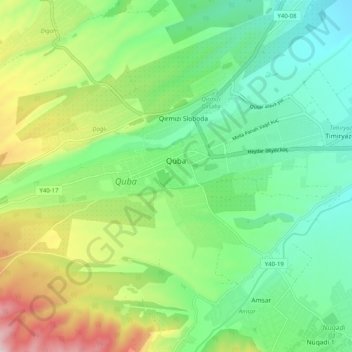
Name: Guba topographic map, elevation, terrain.
Location: Guba, Quba District, Quba-Khachmaz, 4011, Azerbaijan (41.34062 48.45635 41.37552 48.55724)
Average elevation: 623 m
Minimum elevation: 460 m
Maximum elevation: 963 m
Thank you for supporting this site ❤️
Make a donation
Make a donation