
Thank you for supporting this site ❤️
Make a donation
Make a donation
Banjaroyo topographic map
Click on the map to display elevation.
Thank you for supporting this site ❤️
Make a donation
Make a donation
About this map
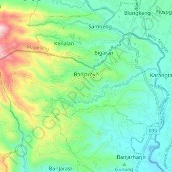
Name: Banjaroyo topographic map, elevation, terrain.
Average elevation: 293 m
Minimum elevation: 124 m
Maximum elevation: 734 m
Thank you for supporting this site ❤️
Make a donation
Make a donation
Other topographic maps
Click on a map to view its topography, its elevation and its terrain.
Kelurahan Ngargosari
Indonesia > Special Region of Yogyakarta > Kulon Progo > Ngargosari
Average elevation: 615 m
Thank you for supporting this site ❤️
Make a donation
Make a donation
Waduk Sermo
Indonesia > Special Region of Yogyakarta > Kulon Progo > Hargowilis
Average elevation: 171 m