
Thank you for supporting this site ❤️
Make a donation
Make a donation
Calovébora topographic map
Click on the map to display elevation.
Thank you for supporting this site ❤️
Make a donation
Make a donation
About this map
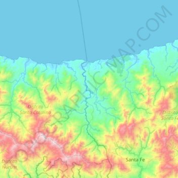
Name: Calovébora topographic map, elevation, terrain.
Location: Calovébora, Distrito Santa Fé, Veraguas, Panamá (8.53611 -81.23359 8.88803 -80.72534)
Average elevation: 392 m
Minimum elevation: -1 m
Maximum elevation: 1,880 m
Thank you for supporting this site ❤️
Make a donation
Make a donation
Other topographic maps
Click on a map to view its topography, its elevation and its terrain.