
Thank you for supporting this site ❤️
Make a donation
Make a donation
Puerto Vidal topographic map
Click on the map to display elevation.
Thank you for supporting this site ❤️
Make a donation
Make a donation
About this map
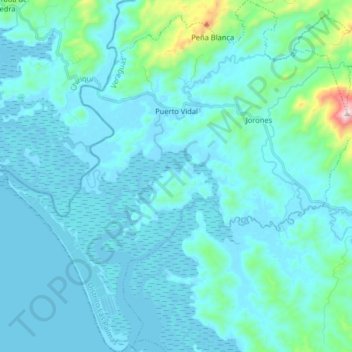
Name: Puerto Vidal topographic map, elevation, terrain.
Location: Puerto Vidal, Distrito Las Palmas, Veraguas, Panamá (7.93942 -81.68297 8.09896 -81.52229)
Average elevation: 72 m
Minimum elevation: -4 m
Maximum elevation: 764 m
Thank you for supporting this site ❤️
Make a donation
Make a donation
Other topographic maps
Click on a map to view its topography, its elevation and its terrain.
Cerro Negro
Panamá > Veraguas > Distrito Las Palmas > El Rincón > Cerro Negro
Average elevation: 166 m