Al-Anbar Governorate topographic map
Interactive map
Click on the map to display elevation.
About this map
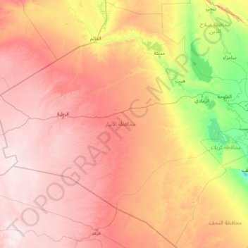
Name: Al-Anbar Governorate topographic map, elevation, terrain.
Location: Al-Anbar Governorate, Iraq (30.67312 38.79367 35.10941 44.15959)
Average elevation: 399 m
Minimum elevation: 9 m
Maximum elevation: 1,006 m
Anbar is one of the driest governorates in Iraq's western desert climate. Some of Al Anbar is part of the Syrian Desert, characterized by steppe and desert terrain. Most of Al Anbar is considered as a topographical continuation of the Arabian Peninsula plateau region. It has some small hills and a number of wadis, including Wadi Hauran. Given a decline in land preservation and a lack of natural vegetation, the land is often exposed to the elements and prone to severe erosion.
Other topographic maps
Click on a map to view its topography, its elevation and its terrain.
Shatt al-Arab
Iraq > Al-Basra Governorate > Qaryat al Fayyadi
Shatt al-Arab, Qaryat al Fayyadi, Abu Al-Khassib Central Subdistrict, Abu Al-Khassib District, Al-Basra Governorate, Iraq
Average elevation: 9 m
Qada Raniyah
Iraq > Sulaymaniyah Governorate
Qada Raniyah, Chwar Qurna Subdistrict, Ranya District, Sulaymaniyah Governorate, Iraqi Kurdistan Region, Iraq
Average elevation: 1,075 m
Hayy al-Auropa
Iraq > Nineveh Governorate > Mosul
Hayy al-Auropa, Mosul, Mosul Central Subdistrict, Mosul District, Nineveh Governorate, Iraq
Average elevation: 253 m
Baghdad
Baghdad, Green Zone Municipality, Baghdad Governorate, Iraq
Average elevation: 36 m
Administrative Boundary
Administrative Boundary, Al-Kufah Central Subdistrict, Al-Kufah District, Al-Najaf Governorate, Iraq
Average elevation: 34 m
Shangal
Shangal, Sijnar Central Subdistrict, Sinjar District, Nineveh Governorate, Iraq
Average elevation: 542 m
Al-Karrada Municipality
Iraq > Baghdad Governorate > Baghdad
Al-Karrada Municipality, Baghdad, Al-Karrada Subdistrict, Al-Rusafa District, Baghdad Governorate, Iraq
Average elevation: 36 m
کەسنەزان
Iraq > Erbil Governorate > کەسنەزان
کەسنەزان, Kasnazan Subdistrict, Erbil Plains District, Erbil Governorate, Iraqi Kurdistan, 90010, Iraq
Average elevation: 604 m
Amman
Iraq > Al-Basra Governorate > Amman
Amman, Al-Harthah Subdistrict, Al-Basrah District, Al-Basra Governorate, 61020, Iraq
Average elevation: 3 m
Sulaymaniyah
Iraq > Iraqi Kurdistan > Sulaymaniyah
Sulaymaniyah, Iraqi Kurdistan, 46001, Iraq
Average elevation: 977 m
Fallujah
Fallujah, Al-Falujah Central Subdistrict, Al-Falujah District, Al-Anbar Governorate, 31002, Iraq
Average elevation: 49 m
Erbil Governorate
Erbil Governorate, Iraqi Kurdistan, Iraq
Average elevation: 1,089 m
Kawnabak
Iraq > Iraqi Kurdistan > Kawnabak
Kawnabak, Aqrah District, Dohuk, Iraqi Kurdistan, Iraq
Average elevation: 427 m
Shatt al-Arab
Iraq > Al-Basra Governorate > Az Zubayr
Shatt al-Arab, Az Zubayr, Al-Basra Governorate, 601010, Iraq
Average elevation: 8 m
Rashdiya
Iraq > Baghdad > Al Maslakh
Rashdiya, Al Maslakh, Adhamiyah, Baghdad, Iraq
Average elevation: 38 m