
Make a donation
Grant County topographic map
Click on the map to display elevation.
Make a donation
About this map
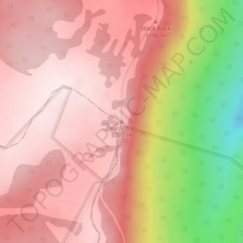
Name: Grant County topographic map, elevation, terrain.
Location: Grant County, West Virginia, United States, Bear Rocks (39.07313 -79.29819 39.07323 -79.29809)
Average elevation: 1,096 m
Minimum elevation: 756 m
Maximum elevation: 1,246 m
Make a donation
Other topographic maps
Click on a map to view its topography, its elevation and its terrain.
Islands Of The Potomac Wildlife Management Area
Average elevation: 179 m
Make a donation
Make a donation
Pea Ridge
United States > West Virginia > Cabell County > Barboursville > Tallwood Acres
Average elevation: 197 m
Make a donation
Fairlea
United States > West Virginia > Greenbrier County > Cedar Knoll Trailer Park
Average elevation: 639 m
Make a donation
Make a donation
Hooverson Heights
United States > West Virginia > Brooke County > Hooverson Heights
Average elevation: 274 m
Make a donation
Make a donation
Make a donation
Make a donation
Make a donation
Make a donation
Make a donation
Make a donation
Make a donation
Canaan Valley Resort State Park
United States > West Virginia > Tucker County
Average elevation: 1,033 m
Addison (Webster Springs)
United States > West Virginia > Webster County
Webster Springs is located at 38°28′34″N 80°24′36″W / 38.47611°N 80.41000°W / 38.47611; -80.41000 (38.476192, -80.410025), along the Elk River. According to the United States Census Bureau, the town has a total area of 0.47 square miles (1.22 km2), of which 0.45 square miles (1.17 km2) is…
Average elevation: 602 m
Make a donation
Make a donation
Clay
United States > West Virginia > Clay County
The city of Charleston, the state capitol, is approximately 40 miles (64 km) from Clay to the southwest. Clay is centrally located within Clay County at 38°27′46″N 81°4′48″W / 38.46278°N 81.08000°W / 38.46278; -81.08000 (38.462855, -81.080024), along the Elk River and West Virginia Route…
Average elevation: 312 m
Make a donation
Pinnacle Rock State Park
United States > West Virginia > Mercer County > Nemours
Average elevation: 772 m
Make a donation
Make a donation
Make a donation
Make a donation
Bethlehem
United States > West Virginia > Ohio County
According to the United States Census Bureau, the village has a total area of 3.54 square miles (9.17 km2), all land, at an elevation of 1,243 feet (379 m).
Average elevation: 318 m
Make a donation
West Martinsburg Historic District
United States > West Virginia > Berkeley County > Martinsburg > Rosemont
Average elevation: 149 m
Make a donation
Make a donation
Harpers Ferry National Historical Park
United States > West Virginia > Jefferson County > Bolivar
Average elevation: 161 m
Make a donation