
Thank you for supporting this site ❤️
Make a donation
Make a donation
Castro Valley topographic map
Click on the map to display elevation.
Thank you for supporting this site ❤️
Make a donation
Make a donation
About this map
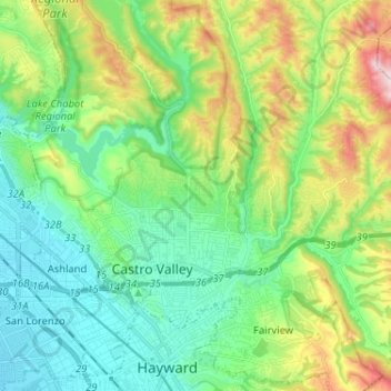
Name: Castro Valley topographic map, elevation, terrain.
Location: Castro Valley, Alameda County, California, United States (37.67438 -122.13113 37.75269 -122.00223)
Average elevation: 120 m
Minimum elevation: -1 m
Maximum elevation: 360 m
Thank you for supporting this site ❤️
Make a donation
Make a donation
Other topographic maps
Click on a map to view its topography, its elevation and its terrain.
Lake Chabot - Main Entrance
United States > California > Alameda County > Castro Valley
Average elevation: 109 m